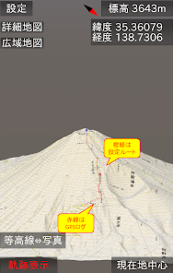
山地図3D - A 3D Map App for Mountain Climbers
山地図3D is an Android app developed by Healthcare Laboratory that provides a 3D representation of topographic maps and photo maps. This app is designed for mountain climbers who need to keep track of their location and plan their routes. It has a unique feature of using the GPU to create a 3D map that can be zoomed in, rotated, and tilted to adjust the angle of the map. The app also allows users to switch between topographic maps and photo maps, and to switch the level of detail of the map from countrywide to neighborhood level.
The app has a GPS tracking feature that can record and display the user's route in real-time, even when switching to other apps. It also has a voice guidance feature that will announce the time, altitude, elevation difference, and horizontal distance difference to the user. The app can save the map for offline use, and it can also load GPX files to display routes on the map.
The app is still under development, and occasionally has some instability issues. However, it is a useful tool for mountain climbers who want to keep track of their location and plan their routes. Users can send feedback or report bugs to the developer via email or app store reviews.